Wildflower Flourishes and Flops
MOHAVE DESERT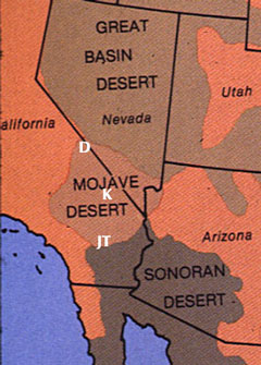 Why is the Mohave Desert represented on this Sonoran Desert site?
The flora of winter annual plants is nearly the same for both deserts,
so much so that the two deserts cannot be separated floristically
on the basis of annuals. The same weather conditions cause the spring
wildflower blooms in both deserts; the main difference is that the
window for the triggering rain occurs earlier in the fall in the higher,
cooler Mohave Desert. However, the Mohave's flower displays are usually
later than the Sonoran's because the colder winters slow growth of
the seedlings. (See the "Predicting
Wildflower Blooms" page.)
Most of the images in this section are from three localities in the Mohave
Desert: Why is the Mohave Desert represented on this Sonoran Desert site?
The flora of winter annual plants is nearly the same for both deserts,
so much so that the two deserts cannot be separated floristically
on the basis of annuals. The same weather conditions cause the spring
wildflower blooms in both deserts; the main difference is that the
window for the triggering rain occurs earlier in the fall in the higher,
cooler Mohave Desert. However, the Mohave's flower displays are usually
later than the Sonoran's because the colder winters slow growth of
the seedlings. (See the "Predicting
Wildflower Blooms" page.)
Most of the images in this section are from three localities in the Mohave
Desert:
D = Death Valley region
K = the Kelso Dunes
JT = Joshua Tree National Park and vicinity
Rainfall data are cited from two stations - Death Valley for the
northern Mohave, and Twentynine Palms (on the north edge of Joshua Tree N.P.) for the southern Mohave. Complete rainfall tables for these two localities are at the end of this section.
A partial history of one spot - the sandy plain east of Twentynine Palms (just northeast of Joshua Tree National Park). The rainfall at Twentynine Palms for these four years was (in inches):
| YEAR |
SEP |
OCT |
NOV |
DEC |
JAN |
FEB |
MAR |
SEASON
TOTAL |
BLOOM
QUALITY |
| 1964 |
1.74 |
2.74 |
0.59 |
0.01 |
0.01 |
0 |
0.07 |
5.16 |
GREAT |
| 1972 |
0 |
0.02 |
0.02 |
0.17 |
0 |
0 |
0 |
0.21 |
POOR |
| 1977 |
3.41 |
0.28 |
0.09 |
0.01 |
0.78 |
0 |
0.14 |
4.71 |
GREAT |
| 1998 |
3.96 |
0 |
0.17 |
0.33 |
??? |
1.25 |
0.82 |
6.53+ |
GOOD+ |
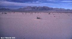
Below left: 1964, a very wet year.
Below right: 1972, after 3 years with almost no rain.
(The views are in different directions, so it is not the same mountain range in all four images.)
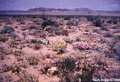
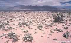
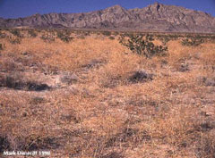
Above left: 1977, the rains returned, but there is less diversity of flowers than in 1964.
Above right: 1998, another wet year, but instead of native wildflowers this area has been taken over by a pernicious exotic weed, Sahara mustard (Brassica tournefortii). (Some nearby areas had good flowers.) First discovered in the United States only in the 1930s, it has by now invaded most of the dry sandy areas of the Sonoran Desert, often to the nearly complete exclusion of native annuals. Such invasive alien species cause immeasurable damage to natural habitats.
********************************************************************
A MORE COMPLETE HISTORY OF MOHAVE BLOOMS
Twentynine Palms rainfall
| YEAR |
SEP |
OCT |
NOV |
DEC |
JAN |
FEB |
MAR |
SEASON
TOTAL |
BLOOM
QUALITY |
| 1964 |
1.74 |
2.74 |
0.59 |
0.01 |
0.01 |
0 |
0.07 |
5.16 |
GREAT |
 Sand
flats east of Twentynine Palms in spring 1964. This was my first springtime
trip to the desert, when I was in high school. Naturally I assumed
that it looked like this every year. I didn't see another such display
until 1973. If you hear about a great wildflower bloom, drop everything
and go! Sand
flats east of Twentynine Palms in spring 1964. This was my first springtime
trip to the desert, when I was in high school. Naturally I assumed
that it looked like this every year. I didn't see another such display
until 1973. If you hear about a great wildflower bloom, drop everything
and go!
Twentynine Palms rainfall
| YEAR |
SEP |
OCT |
NOV |
DEC |
JAN |
FEB |
MAR |
SEASON
TOTAL |
BLOOM
QUALITY |
| 1965 |
0 |
0 |
0.83 |
0 |
0.01 |
0.03 |
0.29 |
1.16 |
POOR |
| 1966 |
0 |
0 |
1.09 |
2.03 |
0.21 |
0.53 |
0.54 |
4.40 |
GOOD? |
| 1967 |
0.06 |
0.19 |
0.12 |
0.38 |
0.08 |
0 |
0 |
0.83 |
POOR |
| 1968 |
1.21 |
0 |
0.21 |
0.83 |
0 |
??? |
0.80 |
3.05+? |
FAIR? |
| 1969 |
0 |
??? |
0 |
0.23 |
0.57 |
0 |
0.08 |
0.88+? |
POOR |
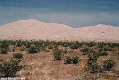 The
Kelso Dunes. The small brown plants between the creosote bushes are
drying skeleton weeds (Eriogonum sp.), the only annual that
was common this year. Even to produce this small display the dunes
there must have been more rain than at 29 Palms 100 miles to the south
(but Death Valley 100 miles north also got less than an inch). Compare
this scene with 1973. The
Kelso Dunes. The small brown plants between the creosote bushes are
drying skeleton weeds (Eriogonum sp.), the only annual that
was common this year. Even to produce this small display the dunes
there must have been more rain than at 29 Palms 100 miles to the south
(but Death Valley 100 miles north also got less than an inch). Compare
this scene with 1973.
Death Valley rainfall.
| 1970 |
0.22 |
0 |
0 |
0 |
0 |
0.45 |
0.31 |
0.98 |
POOR |
| 1971 |
0 |
0 |
0.11 |
0.33 |
0 |
0.01 |
0 |
0.45 |
POOR |
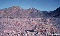 Near
Saratoga Springs, south end of Death Valley. (Compare with 1973.) Near
Saratoga Springs, south end of Death Valley. (Compare with 1973.)
Twentynine Palms rainfall
| 1972 |
0 |
0.02 |
0.02 |
0.17 |
0 |
0 |
0 |
0.21 |
POOR |
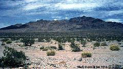 Two
images from the Ord-Newberry-Rodman Mountains area southeast of Barstow,
CA. The first one was taken in June; a May rain greened up the creosote
bushes and caused some shrubs (desert senna, Senna armata)
to flower, but no annuals responded. Two
images from the Ord-Newberry-Rodman Mountains area southeast of Barstow,
CA. The first one was taken in June; a May rain greened up the creosote
bushes and caused some shrubs (desert senna, Senna armata)
to flower, but no annuals responded.
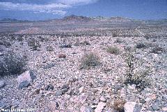
 The
sand plains east of Twentynine Palms shown earlier. The
sand plains east of Twentynine Palms shown earlier.
Twentynine Palms rainfall
| 1973 |
0 |
0.24 |
0.50 |
0 |
0.04 |
0.14 |
0.61 |
1.53 |
GREAT* |
(*There must be some missing or incorrectly recorded rainfall data here!!)
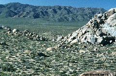 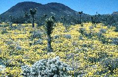
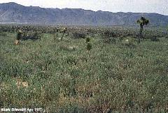 Three
scenes in Pleasant Valley, Joshua Tree National Park (it was a National
Monument in 1973). The first shows that the wildflowers are patchy;
the faint yellow in the bottom of the valley is a couple of square
miles of desert coreopsis (Coreopsis bigelovii), shown closeup
in the second image. The third image, a few miles from the second,
is a field of fiddleneck (Amsinckia sp.). For every showy
desert wildflower there are at least a dozen inconspicuous species. Three
scenes in Pleasant Valley, Joshua Tree National Park (it was a National
Monument in 1973). The first shows that the wildflowers are patchy;
the faint yellow in the bottom of the valley is a couple of square
miles of desert coreopsis (Coreopsis bigelovii), shown closeup
in the second image. The third image, a few miles from the second,
is a field of fiddleneck (Amsinckia sp.). For every showy
desert wildflower there are at least a dozen inconspicuous species.
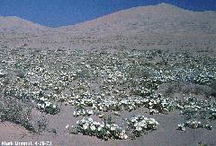 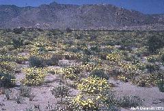
Dune evening primrose (Oenothera deltoidea) in the
Kelso Dunes and a field of desert dandelion (Malacothrix glabrata) on a nearby flat of more
gravelly soil.
Death Valley rainfall
| 1973 |
0 |
1.09 |
0.50 |
0 |
0.34 |
1.00 |
0.57 |
3.50 |
GREAT |
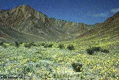 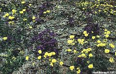
Near Saratoga Springs, south end of Death Valley
(compare with 1971.) Only the desert sunflower (Geraea canescens) shows in the vista, but the
closeup (big file!) reveals several other species of annuals, especially violet caterpillar weed (Phacelia
crenulata).
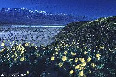 More
hillsides covered with desert sunflower in March. There is still snow
on 11,000 foot Telescope Peak across the valley. The valley floor
is below sea level -- the white covering there is salt. More
hillsides covered with desert sunflower in March. There is still snow
on 11,000 foot Telescope Peak across the valley. The valley floor
is below sea level -- the white covering there is salt.
Twentynine Palms rainfall
| 1974 |
0 |
0 |
0.15 |
0 |
1.03 |
0.48 |
0 |
1.66 |
FAIR |
| 1975 |
0 |
0.44 |
0.13 |
0.10 |
0 |
0.02 |
0.20 |
0.89 |
POOR |
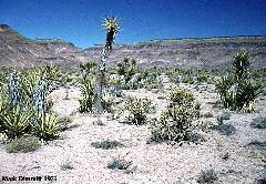 Near
the Kelso dunes on a bajada of the Providence Mountains. Near
the Kelso dunes on a bajada of the Providence Mountains.
Twentynine Palms rainfall
| 1976 |
2.04 |
0.02 |
0.02 |
0.02 |
0 |
1.57 |
0.09 |
3.76 |
GOOD? |
| 1977 |
3.41 |
0.28 |
0.09 |
0.01 |
0.78 |
0 |
0.14 |
4.71 |
GREAT |
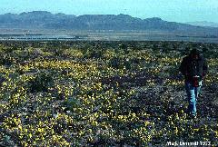
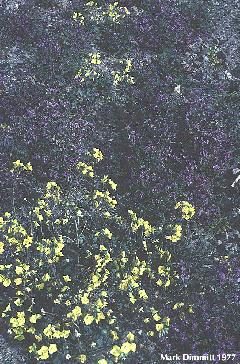 North
bajada of the Newberry Mountains southeast of Barstow, CA. The conspicuous
yellow sun cups (Camissonia brevipes) conceals the more muted
violet caterpillar weed. North
bajada of the Newberry Mountains southeast of Barstow, CA. The conspicuous
yellow sun cups (Camissonia brevipes) conceals the more muted
violet caterpillar weed.
 Sand
flats east of Twentynine Palms, CA. Sand
flats east of Twentynine Palms, CA.
Twentynine Palms rainfall
| 1978 |
0.05 |
0 |
0 |
0.58 |
2.07 |
0.91 |
0.89 |
4.50 |
GOOD+ |
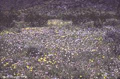 Nopah
Mountains in the Death Valley region. The lavender flowers are Phacelia
fremontii. Nopah
Mountains in the Death Valley region. The lavender flowers are Phacelia
fremontii.
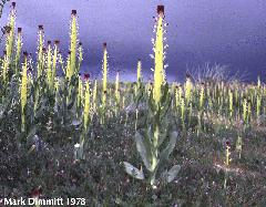 Northwestern
Mohave Desert near China Lake, CA. Desert candle (Caulanthus inflatus)
is one of the few annuals that does not also occur in the Sonoran
Desert. Northwestern
Mohave Desert near China Lake, CA. Desert candle (Caulanthus inflatus)
is one of the few annuals that does not also occur in the Sonoran
Desert.
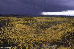 A
field of desert coreopsis near China Lake with an approaching thunderstorm
- a rare Mohave event. A
field of desert coreopsis near China Lake with an approaching thunderstorm
- a rare Mohave event.
 An
extensive , dense field of desert sunflowers near Barstow, CA. This
patch was about four miles wide and three feet tall, growing on normally
barren desert pavement (notice the few creosote bushes protruding
above the flowers). Click here
for a really big image. An
extensive , dense field of desert sunflowers near Barstow, CA. This
patch was about four miles wide and three feet tall, growing on normally
barren desert pavement (notice the few creosote bushes protruding
above the flowers). Click here
for a really big image.
Twentynine Palms rainfall
| 1979 |
0.06 |
0.31 |
1.37 |
0.28 |
1.12 |
0.65 |
0.78 |
4.57 |
GOOD? |
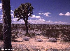 Joshua
tree forest on Edwards Air Force Base. No evidence of annuals here. Joshua
tree forest on Edwards Air Force Base. No evidence of annuals here.
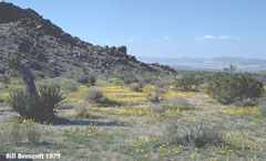 Some
annuals bloomed near Joshua Tree National Monument (now N. Park). Some
annuals bloomed near Joshua Tree National Monument (now N. Park).
Twentynine Palms rainfall
| 1980 |
0 |
0 |
0 |
0.25 |
0.83 |
2.45 |
1.08 |
4.61 |
POOR? |
| 1981 |
1.65 |
0.03 |
0 |
0 |
0.84 |
0.12 |
1.12 |
3.76 |
FAIR? |
| 1982 |
0.10 |
0 |
0.05 |
0 |
0.82 |
0 |
0.34 |
1.31 |
POOR |
| 1983 |
0.53 |
0 |
0.51 |
2.46 |
0.50 |
0.88 |
2.40 |
7.28 |
GOOD? |
| 1984 |
1.22 |
1.23 |
0.20 |
0.90 |
0 |
0 |
0 |
3.55 |
GOOD? |
| 1985 |
0 |
0 |
0.62 |
1.08 |
0.33 |
0.08 |
0 |
2.11 |
POOR? |
| 1986 |
0.91 |
0 |
0.42 |
0.36 |
0.29 |
0.65 |
0.21 |
2.84 |
FAIR? |
| 1987 |
0 |
0.39 |
0.15 |
0.58 |
0.03 |
0.23 |
0.16 |
1.54 |
POOR |
| 1988 |
0.72 |
0.92 |
1.07 |
0.99 |
0.47 |
0.67 |
0.16 |
5.00 |
GOOD? |
| 1989 |
0 |
0 |
0 |
0.04 |
0.81 |
0 |
0.70 |
1.55 |
POOR |
| 1990 |
0.01 |
0 |
0 |
0.47 |
0.02 |
0.06 |
0.05 |
0.61 |
POOR |
| 1991 |
0.09 |
0.13 |
0 |
0 |
0.55 |
0.41 |
1.23 |
2.41 |
POOR |
| 1992 |
0.76 |
0.07 |
0 |
1.06 |
0.23 |
2.23 |
2.03 |
6.38 |
FAIR? |
| 1993 |
0 |
0.30 |
0 |
0.87 |
2.63 |
0.95 |
0.14 |
4.89 |
FAIR? |
| 1994 |
0 |
0.04 |
0.25 |
0.24 |
0.15 |
0.47 |
0.83 |
1.98 |
POOR |
| 1995 |
0.20 |
0 |
0.16 |
0.88 |
2.13 |
0.86 |
0.29 |
4.52 |
POOR? |
| 1996 |
0.13 |
0 |
0 |
0 |
0.05f |
0.30 |
0.12 |
0.60 |
POOR |
| 1997 |
0 |
0.03 |
0.25 |
0.06 |
0.51 |
0.01 |
??? |
0.86 |
POOR |
| 1998 |
3.96 |
0 |
0.17 |
0.33 |
??? |
1.25 |
0.82 |
6.53 |
GOOD+ |
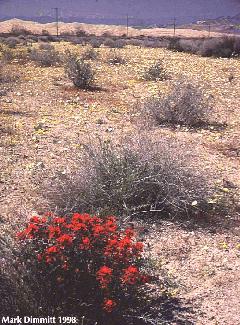 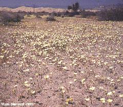 Though 1998 was one of the wettest years ever, the Kelso Dunes (background)
had almost no flowers. But there were patches nearby; this wash channel
was carpeted with pale yellow scale-bud (Anisocoma acaulis)
and bright yellow Eriophyllum wallacei. The red flowers are
Indian paintbrush (Castilleja chromosa), a perennial parasite.
This spring produced stupendous wildflower displays from central Baja California all the way north to Death Valley. Why this area flopped is a mystery.
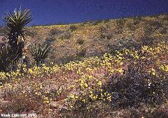 The
Newberry Mountains and adjacent ranges southeast of Barstow, CA were
almost completely carpted with sun cups. Many other wildflowers were
present but their colors were mostly swamped by the sea of yellow.
Click here to see some of the other
species in a huge (500K) image. The
Newberry Mountains and adjacent ranges southeast of Barstow, CA were
almost completely carpted with sun cups. Many other wildflowers were
present but their colors were mostly swamped by the sea of yellow.
Click here to see some of the other
species in a huge (500K) image.
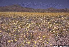 Along
Interstate 40 between Barstow and Needles, CA on the border between
the Sonoran and Mohave deserts. This blanket of desert sunflowers
was 10 miles wide and 40 miles long. Along
Interstate 40 between Barstow and Needles, CA on the border between
the Sonoran and Mohave deserts. This blanket of desert sunflowers
was 10 miles wide and 40 miles long.
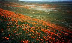 The Antelope Valley north of Los Angeles made a great show.
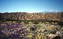 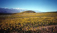
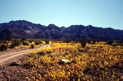 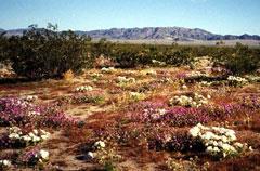
The above four images from the Death Valley region contributed by Ron Fridlind reveal a widespread, spectacular bloom as occurs very rarely.
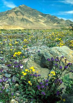 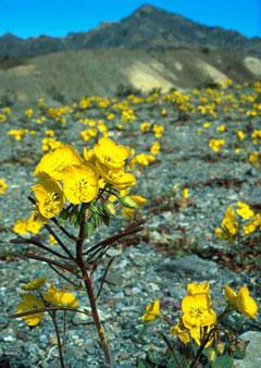
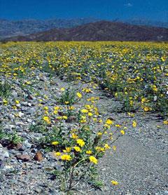 These three images contributed by Stephen Ingram are also from Death Valley. These three images contributed by Stephen Ingram are also from Death Valley.
**************************************************
Here are the full rainfall tables for two Mohave Desert sites
WINTER RAINFALL DATA, DEATH VALLEY
| YEAR |
SEP |
OCT |
NOV |
DEC |
JAN |
FEB |
MAR |
SEASON
TOTAL |
BLOOM
QUALITY |
| 1964 |
1.47 |
0.33 |
0.23 |
0 |
0 |
0 |
0.03 |
2.06 |
? |
| 1965 |
0 |
0 |
0.29 |
0 |
0.01 |
0.07 |
0.55 |
0.92 |
POOR |
| 1966 |
0 |
0 |
1.09 |
2.03 |
0.21 |
0.53 |
0.54 |
4.40 |
GREAT? |
| 1967 |
0.06 |
0.19 |
0.12 |
0.38 |
0.08 |
0 |
0 |
0.83 |
POOR |
| 1968 |
1.21 |
0 |
0.21 |
0.83 |
0 |
1.16 |
0.80 |
4.21 |
GOOD? |
| 1969 |
0 |
0.05 |
0 |
0.23 |
0.57 |
0 |
0.08 |
0.93 |
FAIR? |
| 1970 |
0.22 |
0 |
0 |
0 |
0 |
0.45 |
0.31 |
0.98 |
POOR |
| 1971 |
0 |
0 |
0.11 |
0.33 |
0 |
0.01 |
0 |
0.45 |
POOR |
| 1972 |
0 |
0.02 |
0.02 |
0.17 |
0 |
0 |
0 |
0.21 |
POOR |
| 1973 |
0 |
1.09 |
0.50 |
0 |
0.34 |
1.00 |
0.57 |
3.50 |
GREAT |
| 1974 |
0 |
0 |
0.15 |
0 |
1.03 |
0 |
0.48 |
1.66 |
POOR |
| 1975 |
0 |
0.44 |
0.13 |
0.10 |
0 |
0.02 |
0.20 |
0.89 |
POOR |
| 1976 |
2.04 |
0.02 |
0.02 |
0.02 |
0 |
1.57 |
0.09 |
3.76 |
GOOD? |
| 1977 |
3.41 |
0.28 |
0.09 |
0.01 |
0.78 |
0 |
0.14 |
4.71 |
GOOD? |
| 1978 |
0.05 |
0 |
0 |
0.58 |
2.07 |
0.91 |
0.89 |
4.50 |
GREAT |
| 1979 |
0.06 |
0.31 |
1.37 |
0.28 |
1.12 |
0.65 |
0.78 |
4.57 |
GREAT? |
| 1980 |
0 |
0 |
0 |
0.25 |
0.83 |
2.45 |
1.08 |
4.61 |
GOOD? |
| 1981 |
1.65 |
0.03 |
0 |
0 |
0.84 |
0.12 |
1.12 |
3.76 |
FAIR? |
| 1982 |
0.10 |
0 |
0.05 |
0 |
0.82 |
0 |
0.34 |
1.31 |
POOR |
| 1983 |
0.53 |
0 |
0.51 |
2.46 |
0.50 |
0.88 |
2.40 |
7.28 |
GREAT? |
| 1984 |
1.22 |
1.23 |
0.20 |
0.90 |
0 |
0 |
0 |
3.55 |
GOOD? |
| 1985 |
0 |
0 |
0.62 |
1.08 |
0.33 |
0.08 |
0 |
2.11 |
POOR? |
| 1986 |
0.91 |
0 |
0.42 |
0.36 |
0.29 |
0.65 |
0.21 |
2.84 |
FAIR? |
| 1987 |
0 |
0.39 |
0.15 |
0.58 |
0.03 |
0.23 |
0.16 |
1.54 |
POOR |
| 1988 |
0.72 |
0.92 |
1.07 |
0.99 |
0.47 |
0.67 |
0.16 |
5.00 |
GOOD? |
| 1989 |
0 |
0 |
0 |
0.04 |
0.81 |
0 |
0.70 |
1.55 |
POOR |
| 1990 |
0.01 |
0 |
0 |
0.47 |
0.02 |
0.06 |
0.05 |
0.61 |
POOR |
| 1991 |
0.09 |
0.13 |
0 |
0 |
0.55 |
0.41 |
1.23 |
2.41 |
POOR |
| 1992 |
0.76 |
0.07 |
0 |
1.06 |
0.23 |
2.23 |
2.03 |
6.38 |
GOOD? |
| 1993 |
0 |
0.30 |
0 |
0.87 |
2.63 |
0.95 |
0.14 |
4.89 |
POOR? |
| 1994 |
0 |
0.04 |
0.25 |
0.24 |
0.15 |
0.47 |
0.83 |
1.98 |
POOR |
| 1995 |
0.20 |
0 |
0.16 |
0.88 |
2.59 |
0.17 |
0.31 |
4.31 |
FAIR? |
| 1996 |
0 |
0.04 |
0 |
0.07 |
0 |
0.33 |
0.15 |
0.59 |
POOR |
| 1997 |
0 |
0.42 |
0 |
0.11 |
0 |
0.01 |
0 |
0.54 |
POOR |
| 1998 |
1.48 |
0 |
0.11 |
0.52 |
0.09 |
2.31 |
0.74 |
5.25 |
GREAT |
| MEAN |
|
|
|
|
|
|
|
2.93 |
|
WINTER RAINFALL DATA, TWENTYNINE PALMS CA
| YEAR |
SEP |
OCT |
NOV |
DEC |
JAN |
FEB |
MAR |
SEASON
TOTAL |
BLOOM
QUALITY |
| 1964 |
1.74 |
2.74 |
0.59 |
0.01 |
0.01 |
0 |
0.07 |
5.16 |
GREAT |
| 1965 |
0 |
0 |
0.83 |
0 |
0.01 |
0.03 |
0.29 |
1.16 |
POOR |
| 1966 |
0 |
0 |
1.09 |
2.03 |
0.21 |
0.53 |
0.54 |
4.40 |
GOOD? |
| 1967 |
0.06 |
0.19 |
0.12 |
0.38 |
0.08 |
0 |
0 |
0.83 |
POOR |
| 1968 |
1.21 |
0 |
0.21 |
0.83 |
0 |
??? |
0.80 |
3.05 |
FAIR? |
| 1969 |
0 |
??? |
0 |
0.23 |
0.57 |
0 |
0.08 |
0.88 |
POOR |
| 1970 |
0.22 |
0 |
0 |
0 |
0 |
0.45 |
0.31 |
0.98 |
POOR |
| 1971 |
0 |
0 |
0.11 |
0.33 |
0 |
0.01 |
0 |
0.45 |
POOR |
| 1972 |
0 |
0.02 |
0.02 |
0.17 |
0 |
0 |
0 |
0.21 |
POOR |
| 1973 |
0 |
0.24 |
0.50 |
0 |
0.04 |
0.14 |
0.61 |
1.53 |
GREAT |
| 1974 |
0 |
0 |
0.15 |
0 |
1.03 |
0.48 |
0 |
1.66 |
FAIR |
| 1975 |
0 |
0.44 |
0.13 |
0.10 |
0 |
0.02 |
0.20 |
0.89 |
POOR |
| 1976 |
2.04 |
0.02 |
0.02 |
0.02 |
0 |
1.57 |
0.09 |
3.76 |
GOOD? |
| 1977 |
3.41 |
0.28 |
0.09 |
0.01 |
0.78 |
0 |
0.14 |
4.71 |
GREAT |
| 1978 |
0.05 |
0 |
0 |
0.58 |
2.07 |
0.91 |
0.89 |
4.50 |
GOOD+ |
| 1979 |
0.06 |
0.31 |
1.37 |
0.28 |
1.12 |
0.65 |
0.78 |
4.57 |
GOOD? |
| 1980 |
0 |
0 |
0 |
0.25 |
0.83 |
2.45 |
1.08 |
4.61 |
POOR? |
| 1981 |
1.65 |
0.03 |
0 |
0 |
0.84 |
0.12 |
1.12 |
3.76 |
FAIR? |
| 1982 |
0.10 |
0 |
0.05 |
0 |
0.82 |
0 |
0.34 |
1.31 |
POOR |
| 1983 |
0.53 |
0 |
0.51 |
2.46 |
0.50 |
0.88 |
2.40 |
7.28 |
GOOD? |
| 1984 |
1.22 |
1.23 |
0.20 |
0.90 |
0 |
0 |
0 |
3.55 |
GOOD? |
| 1985 |
0 |
0 |
0.62 |
1.08 |
0.33 |
0.08 |
0 |
2.11 |
POOR? |
| 1986 |
0.91 |
0 |
0.42 |
0.36 |
0.29 |
0.65 |
0.21 |
2.84 |
FAIR? |
| 1987 |
0 |
0.39 |
0.15 |
0.58 |
0.03 |
0.23 |
0.16 |
1.54 |
POOR |
| 1988 |
0.72 |
0.92 |
1.07 |
0.99 |
0.47 |
0.67 |
0.16 |
5.00 |
GOOD? |
| 1989 |
0 |
0 |
0 |
0.04 |
0.81 |
0 |
0.70 |
1.55 |
POOR |
| 1990 |
0.01 |
0 |
0 |
0.47 |
0.02 |
0.06 |
0.05 |
0.61 |
POOR |
| 1991 |
0.09 |
0.13 |
0 |
0 |
0.55 |
0.41 |
1.23 |
2.41 |
POOR |
| 1992 |
0.76 |
0.07 |
0 |
1.06 |
0.23 |
2.23 |
2.03 |
6.38 |
FAIR? |
| 1993 |
0 |
0.30 |
0 |
0.87 |
2.63 |
0.95 |
0.14 |
4.89 |
FAIR? |
| 1994 |
0 |
0.04 |
0.25 |
0.24 |
0.15 |
0.47 |
0.83 |
1.98 |
POOR |
| 1995 |
0.20 |
0 |
0.16 |
0.88 |
2.13 |
0.86 |
0.29 |
4.52 |
POOR? |
| 1996 |
0.13 |
0 |
0 |
0 |
0.05f |
0.30 |
0.12 |
0.60 |
POOR |
| 1997 |
0 |
0.03 |
0.25 |
0.06 |
0.51 |
0.01 |
z |
0.86 |
POOR |
| 1998 |
3.96 |
0 |
0.17 |
0.33 |
z |
1.25 |
0.82 |
6.53 |
GOOD+ |
| MEAN |
|
|
|
|
|
|
|
2.89 |
|
|
 Why is the Mohave Desert represented on this Sonoran Desert site?
The flora of winter annual plants is nearly the same for both deserts,
so much so that the two deserts cannot be separated floristically
on the basis of annuals. The same weather conditions cause the spring
wildflower blooms in both deserts; the main difference is that the
window for the triggering rain occurs earlier in the fall in the higher,
cooler Mohave Desert. However, the Mohave's flower displays are usually
later than the Sonoran's because the colder winters slow growth of
the seedlings. (See the "Predicting
Wildflower Blooms" page.)
Most of the images in this section are from three localities in the Mohave
Desert:
 Though 1998 was one of the wettest years ever, the Kelso Dunes (background)
had almost no flowers. But there were patches nearby; this wash channel
was carpeted with pale yellow scale-bud (Anisocoma acaulis)
and bright yellow Eriophyllum wallacei. The red flowers are
Indian paintbrush (Castilleja chromosa), a perennial parasite.


